
Dalian on the Park
The 19th-century history of the neighborhood has definite representation by industries involving the molding of iron into machines, notably locomotives. However, the major industry in Philadelphia in the 19th century, at least as far as revenues, was the textile industry. This article will trace the Dalian on the Park Apartments site from rail cars to textile mill to hotel and then to the Dalian.
Railroads had proliferated in Philadelphia County since the first in 1832, which ran northwest from 9th and Green Streets. Steam locomotives pulled the freight and passenger cars up to the City limits at Vine and South Streets, but were not allowed into what is now Center City due to fears of fires from smokestack embers. The railroad cars were unloaded and freight and passengers were pulled into the City proper by horse- or oxen-drawn carts. For passenger traffic there were horse-drawn omnibuses, which looked like large stagecoaches, pulled without rails on surface streets. In 1858 a new form of transport began within Center City. Rail tracks were laid down 5th and 6th Streets for multi-passenger vehicles pulled by two horses, each vehicle with a driver and conductor (5 cent fare), each traveling between Southwark and Frankford. Despite some initial opposition, within a year there were thirteen streetcar lines carrying 50,000 passengers daily. Streetcars were in demand, and railroad passenger car manufacturers mobilized to make horse-drawn streetcars. First at the site under discussion, 21st and Hamilton Streets, was Kimball & Gorton R. R. Car Manufactory, from 1851 to 1861. Bolton & Dykeman Company Car Works bought out this firm in 1862.
Public transportation, boosters claimed, would eliminate the need for private carriages (sound familiar?). Stabling horses was expensive, and in 1872 an epidemic of equine influenza and deaths of horses accelerated the streetcar operators' search for another source of power. Steam engines were authorized in 1876 but were not popular with soot-stained passengers. In 1883 cable cars, which required major infrastructure, were tried for a few years, unsuccessfully. A trench was dug between the two rails to allow a cable to pull the cars that could hook onto the cable. In 1892 Philadelphia legislation allowed the use of overhead electric lines.

Portion of 1862 map showing Richard Kimball and Lorenzo Gorton's factory.

Ad from around 1860 showing a horse-drawn streetcar at top and a railroad passenger car at bottom. The streetcar is marked for Green St. and Coates St. Coates Street is the former name for Fairmount Avenue.

Portion of 1867 Map of the Whole Incorporated Philadelphia.
The Bolton Dykeman Company Car Works made railroad cars and horse-drawn streetcars.
On the right, the Preston Retreat is labeled Foster Home, although by 1867 it was running as a maternity hospital.
On the left, W. Wood & Co. Woolen Mill is lurking at the northwest corner of Hamilton and 24th Streets.

Street cleaners and horses would be very happy with the invention of the electrically-powered trolley car. Ad from 1862 railroad journal.

Photo of 19th Street next to Baldwin Park during repaving in August 2018.
The outline of a streetcar track can be seen amidst the Belgian blocks. Starting in 1879 the 17th and 19th Streets Passenger Railway Company ran a loop from Carpenter Street, up 19th to Norris Street, over to 17th and back down 17th to Carpenter Street. For a short outside article about streetcars in Philadelphia see here.
One look at the 1859 map in the area around 24th and Hamilton Streets shows a multitude of small cotton and woolen mills. Thomas Wood, with his brother John, started a factory in 1839 that made machines for use in the textile industry. This Fairmount Machine Works was located at 2106 Wood Street. In 1858 William Wood, the son of Thomas Wood, opened a textile mill at 24th and Hamilton, called Mount Vernon Mill. This was a three-story factory measuring 100 feet on all sides. In 1867 further growth compelled him to build six buildings on the four acres between 21st and 22nd Streets between Hamilton and Spring Garden Streets. 700 employees turned Southern cotton and Western wool into clothing sold directly to retailers.

Textiles in all their forms dominate Philadelphia in 1909, just not in our neighborhood.

Map from 1875 showing three generations of the Wood family in the neighborhood:
-
Thomas Wood's Fairmount Machine Works at 2106 Wood Street on both sides of the street with Thomas' home at 2038 Spring Garden Street, and;
-
William Wood and son at the northwest corner of Hamilton and 21st Streets.

Ad circa 1875 from here showing the wares made by Thomas for his son, grandson, and other textile manufacturers.

Hexamer sketch from 1882 of the William Wood & Co. Cotton and Woolen Mills.
The Hexamer sketches would be used for insurance underwriting, describing the construction of the buildings and the type of manufacturing within.

Sketch looking southeast from Spring Garden Street in 1898.
These renderings are always idealized. The grassy rectangle in left foreground was filled with row homes at this time. Image from Philadelphia, Pa., the Book of its Bourse & Co-operating Public Bodies, 1898.
Compare to contemporaneous sketch below.

Sketch looking southeast from Spring Garden Street from the 1902 edition of Philadelphia and Notable Philadelphians (outside link here).
This sketch spaces the buildings out for a clear inspection, but also includes realistic details like the row houses on Spring Garden Street; Knickerbocker Ice in back right; Bement and Miles in back center; and the granary in back left.
By 1942 these structures would be warehouses for Gimbel's Department Store.
The inset shows the original Mount Vernon Mills at 24th and Hamilton Streets.

Wood had a smaller factory at 22nd and Wood Street. The train along Pennsylvania Avenue is seen in back left. Image from Philadelphia, Pa., the Book of its Bourse & Co-operating Public Bodies, 1898.

William Wood's country estate, Woodlea, in Wayne, Pennsylvania, in 1902.
It was sited very near the current Wayne Station stop on the Pennsylvania Railroad. The house was demolished and replaced by a nursing home.

Photo of the northwest corner of 22nd and Pennsylvania Avenue in 1900: a beautiful avenue even with the horse droppings.
The Fairmount Market functioned as the local Whole Foods from 1850 to the 1920's. Notice the nice stone and wrought iron fencing around the vents from the tunnel below Pennsylvania Avenue. Pequa Mills is the building in the right foreground.
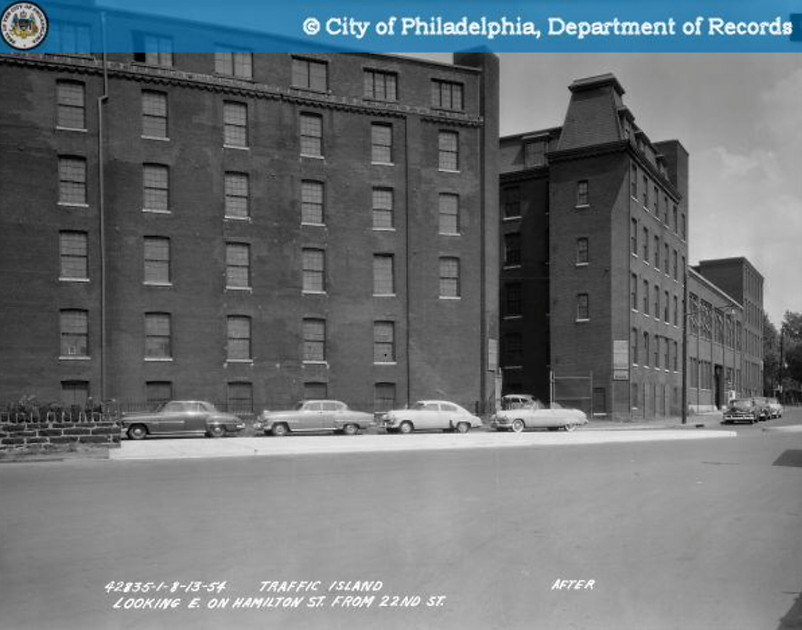
Shiny white new traffic island steering traffic northwest at 22nd Street in 1954. This island is still there, but the stonework around the tunnel venting grills is unfortunately lost. The buildings in the background, the former Pequa Mills/Gimbels, were torn down in 1958.
Just a quick tangent about the tunnel construction beneath Pennsylvania Avenue. The plan was originally for a completely roofed tunnel with two ventilation towers using 20-foot-diameter electric fans to pull fresh air in through ports concealed in the grassy areas and exhausting sooty air up through the towers, like giant chimneys. The railroad company objected to this expense, and the City declined to split the cost, so nine ventilation openings in the roof of the tunnels were created. This compromise resulted in a semi-open cut, which was more expensive than the Reading Railroad's proposed completely open cut and the City's proposed completely roofed tunnel.

Two views from the same viewpoint a few months apart in 1898 (photo from here)
The upper photo shows the steel framing of the tunnel ceiling at the ventilation opening near 25th Street. The lower photo shows the accented opening.
The nine openings along Pennsylvania Avenue today occupy only the middle part of the steel framing and are about 12 x 44 feet, with the long axis parallel to the avenue.

One of two originally proposed ventilation towers with air flow powered by electric fans. Photo from here.
The warehouses were torn down in 1958 and the Franklin Motor Inn was built in 1959. Designed by local architect Sydney Jelinek, it had 292 rooms and an outdoor swimming pool. Many performers from the Uptown Theater on Broad Street stayed here after their shows. For pre-fight isolation, the hotel was popular with boxers, including Joe Frazier (see 1971 New York Times article here). It was later converted to a Best Western and the bar acquired a distinctive clientele (see Philadelphia Magazine article from 2018 here). Here is an excerpt:
New York boxing promoters used to put up their guys here. Hookers idled, businessmen prowled, and the bar used to stay open till 4 a.m. There was an A-list presence too. The last time Martin Luther King ever visited Philly, according to a 1994 piece in the Philadelphia Tribune, he spent the day sick in bed at the Franklin Motor Inn, his favorite hotel in the city. Joe Frazier, a regular, always sat in the same seat, on the far right end of the bar. (Marvis Frazier tells me his father ate breakfast at the hotel at least once a week for more than 30 years, but really came to “play the numbers.”)
Bernard Hopkins, from 1995 to 2005 the middleweight boxing champion of the world, the self-described "black Rocky," would cross the street from his condo #P508 in the south tower of City View to frequent the bar.
Near the end, the smaller of the two buildings included 110 rooms that were rented out to Temple University students while the Best Western Center City Hotel kept its 183 rooms as hotel rooms.
.jpeg)
Postcard from 1960 showing an idealized sketch of the new Franklin Motor Inn.
Up until 1962 there was a row of multi-family townhomes lining Spring Garden Street on the north of this block, represented by the imaginative building on the upper part of this image. These would be torn down and replaced by the Philadelphia County Medical Society in 1964, with a residual gravel surface parking lot at mid-block still remaining to this day. This entire block was just outside the development zone for the Franklin Town Development of 1971.

Free parking, pool, 7 channel color TV! All for $34!
Weekend in Philly, kids!
Mid-century motels tend not to age well, especially motels on concrete pillars situated just off the magnificent Ben Franklin Parkway. The motel closed in October 1983 due to lack of business. One month later it was purchased for $3.1 million by a Maryland firm, Eisinger, Kilbane, & Associates. The firm spent another $4 million to build a 160-seat restaurant and a 140-seat cocktail lounge, and reopened as the Franklin Towne Econo Lodge in March of 1984.
In 1993 the hotel property was purchased by Dalia Shuster and her husband, who always intended to turn it into a condominium tower. In 2006 a 47-story high-rise was proposed as a by-right project in an R15 zoning district with no height limit, a FAR (built floor to land area ratio) of 5.5, and a theoretical maximum density of 160 units per acre. Originally called the Barnes Tower, until the Barnes Foundation protested, the tower name was changed to 22 Parkway (or Parkway22, depending on source). The two nearby neighborhood associations, the Logan Square Neighborhood Association and the Spring Garden Civic Association, opposed the height and lack of street-fronting buildings on 21st Street. Both worked with the developer on a compromise 35-story design. There were also to be a 16-story phase 2 tower on 22nd Street; a seven-story loft building facing 21st Street; and five-story townhouses along Spring Garden Street. That compromise plan would have resulted in 371 total units, with underground parking and a landscaped central court, and was announced as shovel-ready in June of 2008, but it never happened due to a soured economy. What did result from the contentious episode was the passing of a 125-foot zoning overlay for most of the Baldwin Park neighborhood.

2008 photo looking east showing Best Western sign on the building on the right with the original Ben Franklin medallion on the building on the left.

Showing its age.
Photo from 2013 looking east along Hamilton Street.
The four-story fidget-spinner-shaped Best Western Center City Hotel is seen before demolition in 2014. The City View Condos north and south towers are in the background.

The pre-2013 parcel on the left and the 2008 compromise proposal on the right.
Note the separate proposed residential tower at 434 N 21st Street included in the 2008 sketch. That site is being built upon now as 2100 Hamilton Condominiums.

The downsized 37-story tower in the October compromise plan is 407 feet high. For a local comparison, the Alexander Apartments building on 16th and Vine is 375 feet tall.
A new project was approved in 2015. Work began on the Dalian on the Park (outside link here) soon after the demolition of the Best Western. The Whole Foods was the centerpiece, which everyone seemed to appreciate, and it opened in October 2016. Overall, the presence of the new building was a vast improvement over the former motel, even though there were some gripes about the architecture of the building and the loss of a "classic '60s motel" (see Inga Saffron articles here and here). In response to Saffron's critiques, yes, there are three separate parking garages, one for residents; one for Whole Foods employees; and one for Whole Foods shoppers, all with entrances in the alley at mid-block. The last garage has additional entrance and exit openings right in front of the store on Hamilton Street, crossing the sidewalk. Yes, the building facades on 21st and 22nd Street are, to be honest, not especially pedestrian friendly due to lack of promised trees, and the Spring Garden Street side has one entrance to Jefferson physicians. Putting aside the lack of sidewalk vibe and the omission of promised street trees, the residential spaces and 293 living units themselves are quite well-done. Resident amenities include a 24-hour concierge, an infinity pool, yoga studio, fitness center, library, sky terrace, green roof with outdoor grills, and a dog washing room. The complex also includes a CVS pharmacy, a bank, and Jefferson Health physician offices.

The plans for the Dalian in 2015. Despite the generously wide sidewalks, the sidewalk trees were never planted; a missed but still available opportunity.
Street trees, those little green circles in the plan, would definitely soften the facade appearance.

View from the southeastern top floor unit of the Dalian in 2018.

Dalian on the Park in 2019.
The name Dalian comes from the name of the development company, Dalian LLC. That name is an honorific for the wife of one of the principals in the firm, Dalia Fateh, wife of Hossein Fateh. Or is it a reference to the owner of the Best Western since 1993, Dalia Shuster? All Dalias involved can take credit!
The Philadelphia County Medical Society
There is one other building that predates the Dalian on that block. On the southwest corner of 21st and Spring Garden Street is the building owned by the Philadelphia County Medical Society (PCMS).
In 1847 there began an effort by physicians to protect their self-interests. The American Medical Association, a national organization, was founded in 1847; the Medical Society of the State of Pennsylvania in 1848; and the Philadelphia County Medical Society in 1849. All of these were paid for by physicians with the intent of lobbying on behalf of those physicians. There were also the stated goals of improving public health, maintaining quality patient care, and providing education for physicians. Initial meetings of the PCMS were held in the Hall of the College of Pharmacy. In 1856 the society moved into a portion of the College of Physicians of Philadelphia, and by 1863 into a new building at 13th and Locust Street thanks to the bequest of Philadelphia surgeon Thomas Dent Mütter. When the College of Physicians of Philadelphia moved to its current building on 22nd Street near Chestnut Street in 1909. the Central Free Library moved in at 13th and Locust, and the PCMS began to look for its own permanent home. After 15 years of researching possibilities, the PCMS purchased the magnificent former home of George C. Thomas at 2044 Spruce Street, whose widow died in June of 1925. An auditorium was added to the south part of the house along 21st Street. The PCMS settled in for a forty-year stay.
In 1965 the PCMS sold 2044 Spruce Street (sometimes listed as 301 South 21st Street) and moved into their newly constructed current building at 2100-2110 Spring Garden Street. The architectural firm of Nolen and Swinburne designed the structure in what the PCMS building committee chairman described as a compromise between colonial and ultramodern styles. The red brick, the arched windows with white limestone trim, and the building height were meant to blend with the existing townhomes on Spring Garden Street. There is a fortress-like quality to the building, since the auditorium on the north side of the first floor made first floor windows undesirable, except on the south side.
The rise of specialty societies, for example, internal medicine, gastroenterology, etc., would address more specific needs of those specialties and peel off members from the PCMS. Membership numbers fell. In addition, prior to the 1970s, every physician in the county was a member of the PCMS, since this was a requirement for obtaining hospital privileges. When this requirement was voided after a lawsuit, membership fell to just over 2,000 members today. In 2021 the PCMS consolidated its office space onto the third floor, and leased the first two floors, after some remodeling, to one of the 600 Goddard School childcare business franchises.
There is a connection between the first home of the PCMS at 2044 Spruce Street and our neighborhood. George C. Thomas Sr. (1839-1909) made his money as a partner at the investment bank Drexel and Company. His son, George C. Thomas Jr. (1873-1932) became a golf course designer. He spent time at the family's country estate, Bloomfield Farm in Lafayette Hill, just north of Philadelphia. He designed a golf course on the property which he sold in 1908 to a group that turned it into the Whitemarsh Valley Country Club. Bloomfield Farm was adjacent to Erdenheim Farm, the country estate of our neighborhood's Robert Carson (1844-1907) who lived at 2013 Spring Garden Street from 1887 to 1897. Undoubtedly, both Thomas and Carson knew each other. For more on Carson, and the Carson College for Orphan Girls, see our article here.

Southwest corner of 21st and Spring Garden Streets in 1958. These houses would be demolished and in 1965 replaced by the brick building of the Philadelphia County Medical Society. The house on the far right was the former home of John C. Graham, the owner of a trimmings manufactory at what is now the townhomes in the North x Northwest complex.

In 1958 the PCMS was in this magnificent building at 2044 Spruce Street. Since 2003 the building has been a private residence.
This image is from the 100th Anniversary of the Philadelphia County Medical Society published in 1950.

The PCMS building at 2100 Spring Garden Street as of September 2024.
authored by Joe Walsh, September 2020
updated September 2024.